Baratang Fm
Type Locality and Naming
Named after Baratang Island. Type section is Gandhi Ghat – Lorujig Anticline Traverse, Baratang Island. The name Baratang Formation was first proposed by Bolieau (1950) for the thick black clay and limestone sequence deposited prior to the Eocene transgression, after the Baratang Island, where the sequence is well developed. Prior to this, the clay-rich sequence was included within the sandy ‘Port Blair Series’. Anand (1960) mapped Baratang sediments and defined a part of ‘Older Sedimentaries’ in this unit. Subsequently, Chandra et al., (1961) used the term ‘Baratang Formation’, for the soft blue, grey shale with thin sandstone and limestone intercalations, for the sequence unconformably overlying the ‘Older Sedimentaries’ which in turn are overlain by ‘Port Blair Formation’ towards the top Shrivastava et al., (1974) redesignated Baratang Formation as Group. However, following the Code of Stratigraphic Nomenclature (ISSC, NACSN), the term ‘Formation’ has been found to be valid. The nomenclature ‘Baratang Formation’ has been retained in the present work following Pandey et al., 1993 (Pandey and Dave, 1998).
[Original Publication for Formation: Boileau, V.H. (1950). Preliminary report on a geological reconnaissance in the Andaman Island. Progress of Geological Survey of India.].
[Original Publication for Members: Shrivatsava, J.P., Bansal, S.S. and Gadkari, S.D. (1973) Geology of parts of Middle Andaman Island, Progress report of Geological party No 16, Field season 1972-1973, Unpublished report, Oil and Natural Gas Commission, Directorate of Geology, Eastern Circle, Calcutta, Report no. 1490, pp 1-113. Appendix Laboratory reports, filed photographs.].
Holostratotype: Dhani Khari Nala Traverse ‘B’, Baratang Island
Lithology and Thickness
Flysch (Claystone with Sandstone). In the holostratotype, the Dhani Khari Nala Traverse, the formation represents dominantly flysch sediments and consists mainly of claystones, shales and minor interbeds of sandstone and siltstone. Thickness is 458m in the type section.
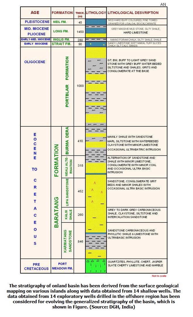
[Figure 1: Generalized Subsurface Stratigraphy of Andaman-Nicobar Basin (from dghindia.gov.in)]
MEMBERS – This unit is subdivided into 5 members (from base to uppermost): Karmatang Sandstone Member; Kalsi Shale Member; Lipa Sandstone Member; Neali Alteration Member; and the Burma Dera Member (clayey):
(1) Karmatang Sandstone Member -- The greywacke type sediments, forming the basal part of Baratang Formation, have been named as Karmatang Sandstone after outcrops of Karmatang Boliu in the eastern part of Middle Andaman. This nomenclature has been retained in subsequent works (Pandey et al., 1993) (Source: Pandey et al., 1998). The hypostratotype section is the Jhinga Nala traverse of Shrivastava et al., (1974). In general, the Karmatang Sandstone consists of sandstone, carbonaceous and phylitic shale. A regular alternation of sandstone and shale is characteristic feature of the unit. In the holostratotype section, the Karmatang Sansdtone Member consists of alternations of dark grey very fine to fine grained, hard, quartzitic sandstone with dark grey slaty shale. The shale is more dominant in the lower part while sandstone dominates in the upper part of the section. At places sediments underwent low-grade metamorphism. In the hypostratotype section in Jhinga Nala section, the member dominantly comprises of sandy shale and shale. Shales are black to grey, salty carbonaceous, ultrabasins of Saddle Hill Intrusives are also observed. Due to rapid alternations of competent and incompetent rocks are acutely folded and faulted, therefore exact determination of thickness is difficult. Based on detailed traverses along the Jhinga Nala and Badamnala, Shrivastava et al., (1974) have calculated a thickness of 2750 ft (846m) for this unit. Lower boundary has a stratigraphic relationship of Karmatang Sandstone Member with the underlying chert/jasper, quartzitic beds of Port Meadow Fm remains mostly obscure.
(2) Kalsi Shale Member -- Named for thick sequence of dark grey, carbonaceous shale exposed on the western part of Middle Andaman by Shrivastava et al., (1972) after the Kalsi Bush Police camp no. 7, where the formation is well exposed (Source: Pandey and Dave, 1998). The member is dominantly clay-rich, comprising mainly of grey to dark grey carbonaceous shale. In the holostratotype section, the Kalsi Shale consists of alternations of shales with clay stones. The shales are grey to very dark grey, carbonaceous, pyritic and rich in organic matter. The claystones are white to cream colored and soft. At some places sandstone bands are also present. At places greenish grey and light maroon shales are also seen. Thin intercalations of sandstone, siltstone and white to cream colored claystones (tuffaceous rock) are also observed. Towards top, it is overlain by Lipa Sandstone Member, but the nature of their contact is not clear.
(3) Lipa Sandstone Member – Named after Lipa Nala, Lipa North Karmatang Traverse, Northern part of Middle Andaman; which is the type section. The holostratotype is the Bandamnala Traverse, Middle Andaman. The dominantly sandy unit, lying unconformably over the Karmatang Sandstone, having much coarser fragments in comparison to Karmatang was named as Lipa Sandstone by Shrivastava et al., (1973) (Pandey and Dave, 1998). The Lipa Sandstone as mapped in the Middle Andamans, shows marked facies change both along and across the regional strike. In the type section, the Lipa Sandstone Member dominantly consists of grey to buff colored, medium to coarse grained, friable, occasionally massive, thick bedded sandstone and thin interbedded sandstone and thin interbeds of conglomerates with pebbles of quartzite, chert/jasper etc. In the upper part, the alternation of dark grey, fine-grained sandstone and grey, brown shale are seen. In the upper part of the sequence, sandstones are light greenish grey, medium to fine grained and moderately hard. In the Badam Nala traverse hypostratotype section, the lower part of the sequence consists of grey to dirty white fine to medium grained sandstone with carbonaceous specks.
(4) Neali Alternation Member – Named after Neali Nala, Northwestern part of Middle Andamans (Neali-south Karmatang traverse), the type section. The holostratotype is the Badam Nala Traverse, Middle Andaman. The alternating sequence of sandstone and shale, overlying the Lipa Sandstone and limited by Burmadera Shale on the top was named as ‘neali Alternation’ by Shrivastava et al., 1973 (Pandey et al., 1993). In the holostratotype section, in the Neali Alal traverse, the Neali Alternation Member consists of alternation and sandstone and shale with minor siltstone towards the top. Towards the base, conglomerates with rounded pebbles of grey to brown sandstone are observed. A Limestone, which serves as a local marker, was named as ‘Parnasala Limestone Member’ by Shrivastava et al., 1974. Due to folding and other structural complications the exact thick of this member is difficult to compute. However, Shrivastava et al., 1974 computed a thick varying from 268m to 345m. The lower contact of the Neali Alternation shows conformable relationship with the underlying Lipa Sandstone and the upper contact of the unit with Bumadera Member is disconformable, as evidenced by the presence of conglomerate and pebble beds at the contact of the two units.
(5) Burma Dera Member -- Named after the type section near Burma Dera Village (Karmatang Boliu Traverse), Middle Andaman. The holostratotype is Neali Nala Traverse, Middle Andaman. The dominantly clayey sequence, lying disconformably or unconformably over the Neali Alternation, was named as Burma Dera Member by Shrivastava et al. (1973) (Pandey and Dave, 1998). The Burma Dera Member is a dominantly clayey unit with thin pebble and sandstone beds in the lower part. Thin beds of siltstone, argillaceous sandstone and calcareous marls are also present in the shale sequence. In the holostratotype section, it dominantly consists of shales with minor sandstone towards the base. The shales are greenish grey to grey with thin bands of siltstone and fine-grained sandstone. At places few thin lenses of sandstone are observed in the shale. The sandstone is observed in the lower part is fine grained. In hypostratotype section, Neali Nala Traverse, the member consists of dark grey to grey, fissile shale with fine grained sandstone and siltstone layers. Thin sandstone streaks are observed in the section. Towards the upper part sandstones are observed. Shrivastava et al. (1974) have calculated the maximum thick of the unit to be around 1340 ft (400 m) along Badamnala traverse in the north, 130 ft (40 m) along Kalsi-6 Saguanala Traverse and Rangat Bakultala Traverse in the south. The thickness is reduced to 1120 ft (341 m) along Kalsi-3 Pitchar nala due to folding and faulting. The dominantly clay-rich Burma Dera Member gives rise to a low topography forming undulating grounds and wide valleys (e.g. Betapur, Saguanala valley, etc.). The lower boundary of Burma Dera Member with the underlying Neali Alternation is disconformable as evidenced by presence of basal conglomerates, dip discordance and lithological changes. The upper boundary of this member has an unconformable contact with the overlying Port Blair Fm representing a significant time gap.
Relationships and Distribution
Lower contact
Distinct unconformity to the underlying Port Meadow Fm
Upper contact
Distinct unconformity to the overlying Port Blair Fm
Regional extent
In Baratang Island, the formation is mainly clayey unit consisting of shales with minor interbeds of sandstone, siltstone. In the South Andaman, the formation mainly consists of sandstone with minor siltstone, shale and conglomerates. The Baratang Formation of these islands can be distinguished from Port Blair Formation by its constituent sandstone and shale which are harder, calcareous, well bedded and contain igneous intrusive rocks. The sandstone at several places shows lateral variation to shale and siltstone showing considerable facies change from north to south in Baratang Island. Due to alternation, sharp facies change and poor exposures, it is not possible to subdivide the formation into different units in South Andaman and Baratang islands (Pandey and Dave, 1998).
(1) Karamatang Sandstone Member -- In the Karmatang Sandstone, alternation of sandstone and shale beds are observed in the Middle Andaman Island. The Karmatang Sandstone has been extensively mapped in the Middle Andaman Island by Shrivastava et al., (1974). It is mainly confined to the eastern part of the area mapped. Its continuity has been traced from Badamnala in the northeast up to Rangat Bay-Amkunj in the south-east. In the northern part, the unit has been repeated due to folding and faulting and hence the width of outcrop is widened. But in the south, width of outcrop is reduced due to compression, tectonic deformation and large-scale ultrabasic intrusions. In the Middle Andamans the Karmatang Sandstone outcrops are well exposed along Badamnala, Jhinga Nala, Dhani Jala, southwest and northeast of North Bert Bay Police Camp along several tributary nalas of the Betapur stream, south of Betapur and around Pandchavati Hill range. A small outcrop of Karmatang Sandstone is also noted south-southwest of Mt. Wood, part of Karmatang sequence in the area north of Betapur and also in the area east northeast of Rangat viz. in Janakpur was originally identified as Older Sedimentaries by Ramachandra et al., (1964), based on its low-grade metamorphic criteria. Shrivastava et al., (1972) included a major part of this sequence of the above two areas into Older Sedimentaries. But after extensive mapping, Shrivastava et al., (1974) suggested that Older Sedimentaries actually comprise of a very small thickness and that a major part of the sequence is made up to ‘Karnatang Sandstone’ (Pandey and Dave, 1998).
(2) Kalsi Shale Member -- The Kalsi Shale is exposed only on the western part of Middle Andaman. Its base is not exposed.
(3) Lipa Sandstone Member -- A more conglomeratic and sandy facies is developed towards north and northeast, except in the area west of Mt. Baker and northeast of Dhani nala, a number of conglomerate beds are developed. In contrast, the unit is less coarse and less sandy towards south and west. Marked lateral facies changes and shoaling of Lipa Sandstone at short distance are observed between Korang Nala and Thoraktran Nala. Similar facies change is also observed to the west between Kalso B.P.O no.3 and Kalso B.P.O. no.4. The Lipa Sandstone resembles to a great extent to the Port Blair Fm, especially on the western and southern side. But the occasional presence of ultrabasic intrusions within Lipa Sandstone precludes their inclusion with Port Blair Formation (Pandey and Dave, 1998). Shrivastava et al., (1974) calculated the thickness of Lipa Sandstone in the Badam Nala traverse to the order of 1450 ft (452m) on the north and 1270 ft (387m) along Kalsi Parnasala traverse in the south. The Lipa Sandstone is fairly well exposed in the Middle Andamans and has been extendively mapped. Besides the type area, the member is well exposed along Korang Nala, Pitchar Nala, Thoraktran Nala and in between Parnasala and Sagua Nala areas. The Lipa Sandstone is also well exposed on the eastern and western units of Bakultala syncline. In the area east of Bakultala, the member is well exposed in a few quarries. Further, it is well exposed between Kaushalyanagar and Kalsi B.P.O. No.7. The Lipa Sandstone is also found well exposed in the area east of Jhinga Nala fault, as well as immediately to the west of the fault (Pandey and Dave, 1998). In the eastern part of the Middle Andamans, this unit rests unconformably over the Karmatang Sandstone. It has a conformable contact with the overlying Neali Alternation.
(4) Neali Alternation Member – no details
(5) Burma Dera Member -- The Burma Dera Member has been extensively encountered in the core of a number of synclines in the Middle Andaman. Some of the best exposures of this unit are encountered along Karmatang-Billi Ground syncline, along Mt. Wood syncline and in area adjoining Parnasala and Ranaghat, on both limbs of Bakultala Saguanala syncline and west of Pahalgaon fault. The outcrops of this member are widest in areas east of Kalsi B.P. camp no. 3,4,6 and west of it in the core of Kalsi-3 syncline. On the eastern side, it is exposed in the core of CuthBert Bay Syncline and on the limbs of Mt. Angelica syncline. Marly layers up to 6” thickness have been observed by Shrivastava et al., 1974 in the shale in the area south of Kalsi-3. In a number of places like Kalso-3 thin alternations of shales and siltstone up to 1 ft thickness have been observed. At places the shales have interbedded layers of white claystone or tuffaceous beds. These are prominent along Korang Nala, nala north of Saguanala forest camp, along Bakultala-Kausalyanagar road. The sandstone interbedded with shales is up to 10ft thick and at places layers and pockets of grits are also associated with shale. In the basal part of Burma Dera Member, thin conglomerate beds alternating with sandstone and shale are also observed (Source: Pandey and Dave, 1998).
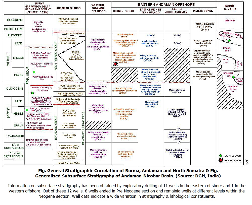
[Figure 2: General Stratigraphic Correlation of Burma, Andaman and North Sumatra (from dghindia.gov.in)]
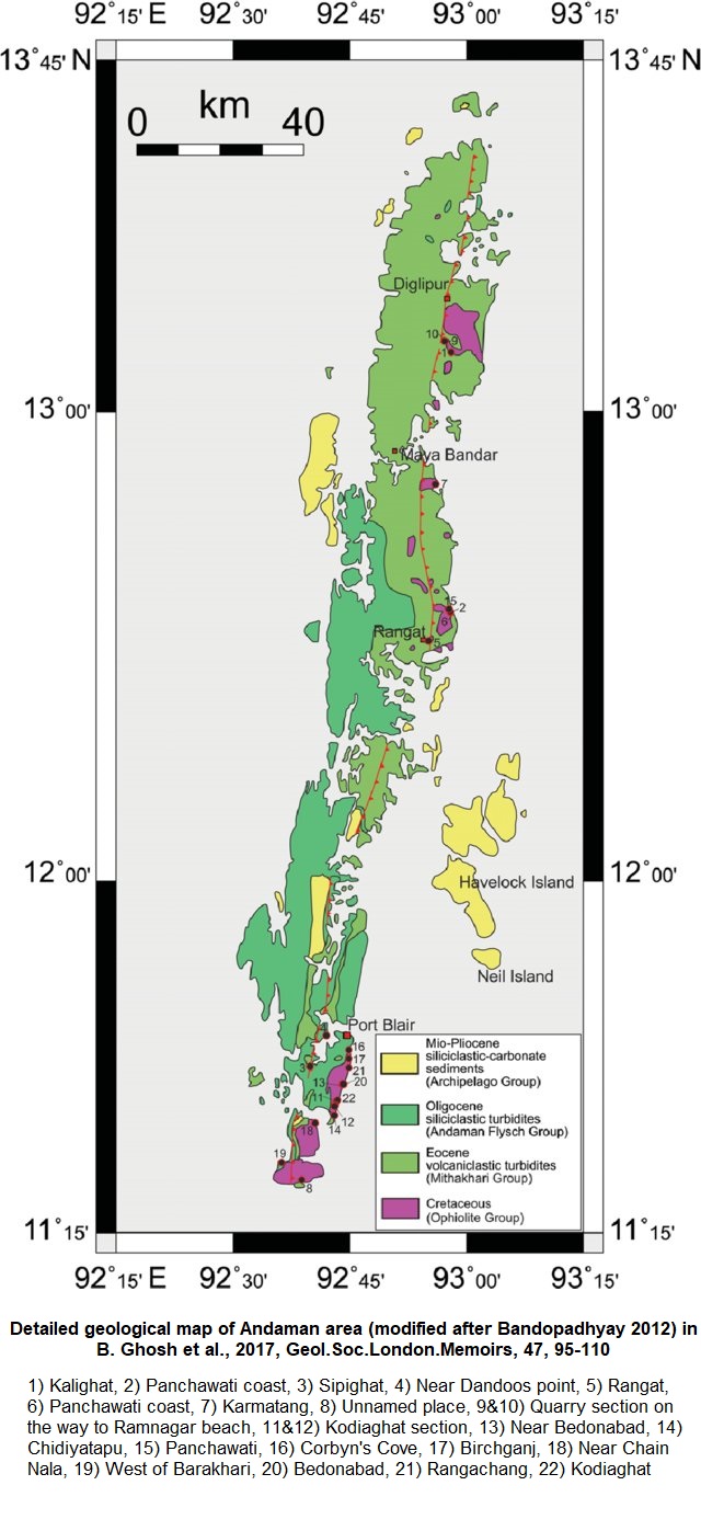
[Figure 3: Detailed geological map of Andaman area (modified after Bandopadhyay 2012) showing locations mentioned in numbers in B. Ghosh et al., 2017, Geo.Soc.London.Memoirs, 47, 95-110)]
GeoJSON
Fossils
Diagnostic foraminifers are rather rare in the Baratang Formation. Miscellanea miscella D' Archiac & Haime, Civillierina vallensis Ruise De Gona, Nummulites sp., and Discocyclina ramaroi (?) Samanta were identified in thin sections of an allochthonous algal limestone. The Baratang Formation includes: Globigerina triloculinoides (Plummer), Globorotalia pseudobulloides (Plummer), G. uncinata (Bolli) and M. aragonensis (Nuttal).
Age
Depositional setting
The lowest sample of the Baratang Formation, examined by Pandey (1972b) is an ooze like material with Globotruncana, Heterohelix assemblage and no benthic foraminifers. In this sample, terrigenous material is marginally higher than that prescribed for an Ooze. Never the less, the ecological parameters of this rock may be inferred to be same as a 'Globigerina Ooze' and the Late Cretaceous basin floor may well be conjectured to be deeper than 3500 meters.
The majority of the indigenous Baratang fauna is constituted by above 90% holomarine agglutinated types-many of them of robust size. The assemblage also includes cold water genera like Pelosina and Saccamina. This arenaceous assemblage, in view of its composition showing cold-water habitat in the tropical latitudes of Andaman, could be referred to abyssal depths of low temperature.
Additional Information


